Collective Action to Reduce Land Degradation - a case study of Village Chitravas, Gogunda Tehsil, District Udaipur, Rajasthan
Jan 18, 2012
This case study documents the impact of collective action in a tribal village in Rajasthan, in regenerating and restoring community forests and reducing soil degradation.
Chitravas is a tribal village inhabited by two clans of the Bhil tribe. Located in the southern Aravali ranges, the village name means ‘home of leopards’ (chitra in the local language refers to a leopard and vas means home or place of abode). Villagers remember a history of dense and rich forest with sparse cultivation in the valley portions of this landscape. However, the rich faunal and floral diversity of this ‘home of the leopard’ has degraded over the years due to various biotic and a-biotic factors. Land degradation, deforestation, drying up of streams, and changing land-use had adversely affected livelihoods of the community. These changes also had an adverse impact on the socio-institutional fabric of the community.
Chitravas is a Gram Panchayat, with four habitations within it - Sakria, Bhamrabara, Pipalsari, and Kundala. The village has an area of over 217 hectares of forestlands, and is situated on the boundary of a wildlife sanctuary.
2.1 FES Intervention
FES’s1 work in the village was initiated in 2001. Initial interactions resulted in the formation of a Village Forest Protection and Management Committee (VFPMC) which after the required registration with the Forest Department initiated work as per their approved micro-plan. However, as activities were initiated, the principle of having “clearly defined user boundaries” overlooked issues of inter village or inter habitation complexity and overlapping user rights People from the Kyara ka Khet habitation (a hamlet of the Rawach revenue village) and the Richwara revenue village (both habitations bordering the forest plot of Chitravas) began to protest for their rights. These inter-village use rights gave rise to the notion of customary use of resources as the basis to decide on the rights and stake over a resource. FES team members and the communities from villages with a stake in the forest plot then came together to finalize a ‘Hakdari list'2. This list helped in deciding membership to the VFPMC. All the 325 families with 999 'hakdars' (above 18 years of age) out of a total population of 1508, all of whom belonged to the Garasia and Gameti tribes, were included as part of the institution. Together they agreed to protect and manage the 217 hectares of forestlands through the arrangement of Joint Forest Management. With this renewed understanding regarding stakeholders (based on the assertion and recognition of the rights of all users) a number of meetings were organized to re-draft the eco-restoration and management plan for the plot which was approved by the Forest department.
2.2 Community participation and physical intervention
 Following the recognition of stakeholders, the community jointly developed context specific rules and regulations for execution of work and management of the forest plot. Recognizing multi-stakeholders spread across different habitations, the community evolved systems of regular meetings, self monitoring and regular negotiation which were in contrast to previous systems which were individually oriented such as the system of “mate”3. Through these processes the communities addressed issues of work efficiency, ownership over their own resources, and most importantly have been able to reduce the importance of traditional power centers.
After the approval of the plans by the forest department, the first physical intervention was to rebuild the stone wall to protect the forest land. Planting of jatropha curacus cuttings along the stone-wall was also done to provide an additional vegetative barrier. A series of Soil and Water Conservation (SWC) measures were constructed which included loose boulder check dams, gully plugs, contour trenches and gabions to ensure in-situ conservation of soil and moisture. Vegetative augmentation of the area was undertaken with the plantation of 50,000 saplings of various local species and sowing of grass seed.
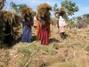
In addition to the activities to regenerate the common lands, women groups were organized to take up livelihood interventions on farm lands. Various activities such as bunding of agricultural fields, providing critical support to enhance infrastructure for potable water and irrigation especially to relatively poorer households, energy conservation measures, kitchen gardens, and pasture development were carried out. These not only led to improving the livelihood base, but the greater impact was in improving women leadership in the area as well as creating space for women’s participation in community decision-making processes.
2.3 Problems
As the work progressed, the village encountered many problems, but the most noticeable one was that of encroachment over the forestland. A villager, Lala Bhuji made an attempt to encroach a patch of around 3-4 bighas (approximately 2.3 acres) of land for agriculture. The villagers gave him time to harvest his crop on the assurance that after the harvest he would rebuild the forest fence on his own. But after the harvest, instead of vacating the plot, Lala Bhuji started preparing the field for another crop and refused to follow the village orders. This time there was large-scale community protests and a number of 'Aam Sabhas'4 were constituted to discuss this issue. Since Lala Bhuji refused to attend these meetings, the community convened these meetings in front of his house. The matter was also taken up with the Panchayat. Finally the community pressure was so intense that Lala had to vacate the encroachment and started participating in the entire process.
2.4 Protection mechanism
After having tried out different protection mechanisms such as paid guards, assigning responsibility to a few individuals, etc. and having repeatedly failed, the community devised its own system called the "Lathi system"5 . If any livestock is found inside the plot the matter is reported to the village committee who, after a meeting, imposes graduated sanctions as per village norms. Since the people from the main village, due to physical distance from the plot, were not able to participate in its protection, it was decided that they would pay more for the produce. Chitravas, which had initially refused membership of representatives from other villages, has now accepted this. The community institution is now adequately represented by all villages with a stake in the forest plot, and the management committee now has members spread over different habitations. Decision making is also now more inclusive. These developments signify a gradual growth and strengthening of the institution.
2.5 Outcomes
The outcome of the work was manifold. The collective strengths of the community were reflected in the improved governance over natural resources and also in improvements in biomass, water and soil health.
a. Improved local governance: Through collectively conserving their forests, pastures and water resources, the community has been able to establish a true form of local self governance, not only limited to a conservation agenda but also encompassing other activities related to socio-cultural-political and economic aspects. Managing the diverse interests within the community, they have been able to promote a focus on relatively poorer households and have evolved norms which are specific to their local context.
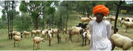
b. Vegetative Improvement: The regeneration efforts have resulted in qualitative as well as quantitative improvements in biomass. The analysis of field data shows 100% increment in the biomass with 301.62 t/ha in the protected plots as against 140.43 t/ha in case of unprotected plots. There is a marked growth in the biodiversity of the area with a composition of 11 trees, 29 shrubs, and 24 grass species in the protected area as against 3 trees, 4 shrubs, and 12 grass species in unprotected plots.
| *values in tonnes per hectare | Tree Biomass | Shrub Biomass | Grass Biomass | Total Biomass | Grass Cover% | Trees per ha | Shrubs per ha | |
| Protected forest plots (supported by FES) | 282.82 | 13.16 | 5.63 | 301.62 | 92.17 | 205 | 3,360 | |
| Unprotected Area | 140.43 | 3.00 | 0.26 | 143.68 | 25.33 | 80 | 640 |
c. Soil improvement: The improvement in biomass has also impacted the soil health of the protected plots. The analysis of the soil indicates a positive trend in the status of Organic Carbon (OC), Nitrogen and available Potash. The reducing trends in case of available phosphorus can be attributed to an increase in organic matter (reports indicate organic matter and available phosphorus are inversely related). The data shows trends towards a normal pH and Electrical Conductivity (EC), together with an increment in the nutritional status of the soil indicating an overall improvement in soil health of the area.
| pH(1:2.5) | EC(ds/m) | OC% | Total- N (ppm) |
Available P2O5 (ppm) |
Available K2O (ppm) |
Available Na (ppm) |
|
| Protected plot | 7.35 | 0.136 | 0.796 | 678.5 | 28.5 | 172.18 | 146.69 |
| Unprotected plot | 7.62 | 0.146 | 0.59 | 501.2 | 29.3 | 138.28 | 146.52 |
d. Improvement in Water regime: Organic matter plays an important part in the local, regional, and global  water, or hydrologic cycle due to its role in promoting water infiltration into soils and storage within the soil. Soils having high organic matter enhance the rapid infiltration of rainwater into the soil. This water may be available for plants to use or it may percolate deep into the subsoil and help to recharge the groundwater supply. Since groundwater is commonly used as a drinking water source for homes and for irrigation, recharging groundwater is important. When the soil's organic matter level is depleted, it is less able to accept water, and results in high levels of runoff and erosion. This means less water for plants and decreased groundwater recharge. In Chitravas, the improvement in biomass and organic matter has improved ground water recharge and ensured that the seasonal stream which originates from the forest lands and which earlier used to remain dry for a major part of the year, now flows for a longer duration. This has improved the supply of water from open wells, many of which were dry prior to project interventions (of the 50 open wells in the village, 40 were earlier dry. After project interventions, only 10 are without water).
3. Conclusion
A majority of India’s tribal communities inhabit the upland and forest dominated landscapes that form a horizontal stretch across the country from the southern parts of the Aravali hill range to the Chotanagpur plateau. The loss of forests, which are primarily located in the uplands, has led to widespread degradation of agricultural farms in the valleys below. Central to the work of ecological restoration in these regions is the endeavour to understand local community institutions, revive collective actions and strengthen tenure arrangement over forests and other common lands in favour of communities who have been managing and using these lands from time-immemorial. Joint forest management arrangements have provided a degree of tenurial security and incentive to local communities to participate in forest protection and restoration activities. In many natural environments that are being modified by human activity there is scope for conservation and livelihoods to be linked and to benefit from each other. An approach that seeks to restore the health of the ecosystems and the services they provide, combined with efforts to strengthen on and off farm incomes, safeguards forests as also contributes to poverty reduction.
Bibliography:
- Forest and poverty: a survey study by K.D. Singh
- Soil erosion rates in India Gurmel Singh, Ram Babu, Pratap Narain, L. S. Bhushan, and I. P. Abrol
- Participatory Forest Management in India - An Analysis of Policy Trends amid ‘Management Change’ - Kulbhushan Balooni, LEAD India Associate
- Hobley, M., Participatory forestry - The process of change in India and Nepal. Rural Development Forestry Study Guide no 3 -. London: Overseas Development Institute.
References:
- FES – Foundation for Ecological Security is an organization working for the ecological restoration and conservation of land and water resources in the uplands and other eco-fragile, degraded and marginalized zones of the country. FES is currently working with 1204 village institutions in 23 districts in seven states across the country and has been protecting 85800 ha of revenue wasteland, degraded forest and Panchayat grazing lands (website: http://www.fes.org.in).
- Hakdari - customary use rights of the community over a piece of land.
- Mate - Work supervisor who is often a powerful person in the village.
- Aam Sabha - General body meeting of the village.
- Lathi system – A system of community forest protection, wherein three persons from three different households protect the plot every day, walking across its length, carrying a stick (lathi). In the evening they hand over the lathis to the next three houses, thereby signifying a handing over of protection duties. The lathis move from house to house across the various habitations, demonstrating a community-based protection system.